Map by mapchart.net - Some rights reserved.
Location
near Speenoge, County Donegal, Ireland
Description
Grianan of Aileach is situated on a hill top near the town of Burt, some 11km west of Derry in County Donegal overlooking Lough Foyle and Lough Swilly.
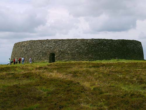
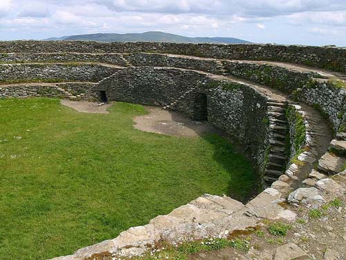
Grianan of Aileach is a stone ring fort surrounded by earthworks on the top of Greenan Mountain, some 244 metres high. The fort has an internal diameter of 23.4m, and has a massive stone wall almost 4m thick. There are several stairways giving access to the top of the walls. Within the walls are a number of small chambers. The Grianan of Aileach is also known by its Irish name of Grianan Ailigh, and the name is roughly translated as "Stone Fortes (or Temple) of the Sun" .
The fort was restored in the 19th century, but much of the original drystone masonry structure remains intact at ground level. The restoration team used fallen stones to build on the original foundation, but had to bring in other stone from the area to replace missing stones. The main entrance one the east is 1.12m wide by 1.86m high with a lintel overhead and a depth of 4.65m long. The original gateway did not have a lintel. The inside has three terraces with stairways leading from one level to the next. There are two wall passages, with one on the south side and the other on the north east. These passages run towards the gateway but do not connect with it, so their original purpose is unclear. The passages are roughly 0.5m wide with height ranging from 60cm to 1.4m high, and the longest one is over 20m long.
Most of the ramparts have been eroded by time. There used to be a set of inner and outer ramparts with the outer ramparts enclosing an area of about 5 acres.
Facilities
The fort is open to the public, with a self-guide leaflet available for visitors.
History
The Grianan of Aileach is an Iron Age stone fortress and is believed to have been the seat of the Kingdom of Aileach. It was a political and cultural centre during the time of the early Irish chieftains from approximately 800BC to 1200AD. After the Norman invasion, the Kingdom of Aileach gradually lost control of the territory, and the fort was destroyed by Muirchertach Ua Briain, the King of Munster in 1101. By the end of the 12th century, the Normans controlled most of the lands of Aileach.
The fortress fell into ruin over the centuries. George Petrie surveyed the fort in the 1830s, when it was still a ruin, and at that time most of the wall remaining was less than 1.5m tall. It was rebuilt between 1874 and 1878, and the walls and main stone features have been restored. The restoration was intended to preserve the historic authenticity of the structure. The restoration work was directed by Dr. Walter Bernard. The site is now owned by the Irish government. Further restoration was undertaken by the Office of Public Works in 2001 after part of the wall collapsed. The restored areas can easily be seen, being of different colour and pattern to the original walls. Some parts of the upper walls have been cemented in place for safety. An iron gate was set into the entrance way.
Other Castles in the Area
Raphoe Castle, County Donegal
Altinaghree Castle, County Tyrone
|
|
|
|
|

Grianan of Aileach, Donegal, Ireland.
Photograph by Jon Sullivan. License: Public Domain. (view image details)
|

nterior view of Grianan of Aileach
Photograph by Jon Sullivan. License: Public Domain. (view image details)
|
|
© OpenStreetMap contributors licensed as CC BY-SA
|
|
|

